
Tuvoc Technologies helps businesses cultivate spatial data through bespoke GIS software development services, resulting in data-driven, intelligent business decisions. As a transformative GIS development company, we build cost-effective, secure, custom, and scalable GIS solutions. Our GIS solutions are the fulcrum of operations, reducing inaccuracies and enhancing workflows with exceptional geospatial insights.
Contact Our Experts


Tuvoc’s custom GIS software can be the fulcrum of your business to turn it into a sustainable growth engine. Ours are custom GIS software development services that facilitate location intelligence, data interaction, and advanced mapping. We align our services with enterprises’ objectives and the government’s planning. Consequently, we stimulate incomparable growth through geospatial innovation.
Hire Expert DevelopersWe develop bespoke custom GIS application development solutions streamlined to your needs. From mapping to analysis, our GIS applications make workflow simple and decision-making efficient. Our solutions are synonymous with accuracy and flexibility, which is reflected in our solutions made for industry standards and business goals with precision.
Our spatial data management and integration services aggregate data from imagery, sensors, ERP, and on-field sources into our GIS platform. This accurate synchronization of geospatial data allows businesses to make correct and consistent decisions. We ensure businesses have effortless data access across departments, allowing them to plan and operate smarter.
We develop interactive dashboards and maps that simplify the process of understanding complicated data. Spatial trends can be analyzed, assets can be tracked, and fast action can follow using real-time mapping. Our visualization and mapping apps empower decision-making processes across urban planning, logistics, and agriculture sector enterprises.
Tuvoc innovates GIS mobile app development solutions that also possess offline capabilities. On-field personnel can collect, access, and edit geospatial data. We enhance our mobile GIS solutions for asset tracking, surveillance, and information gathering, even in the ramp-off areas. We ensure your teams are efficient even under isolated or low-connectivity conditions.
We analyze GIS software integrating remote sensing & drone data to help your business track and monitor your assets. Be it environment, agriculture, logistics, or construction, our GIS solutions analyze imagery to extract geospatial information. Further, we turn the raw data into geospatial intelligence to drive precise decisions.
We incorporate spatial analysis with AI and ML to highlight trends, optimize business activity, and predict results. Tuvoc enhanced GIS analytics to bestow businesses with the ability to assign resources stratgize location-based activities, and design predictive algorithms. Resultantly, we empower businesses to reach definite conclusions using raw geospatial intelligence.
We provide GIS database design and development services to build spatial databases that automatically adjust while delivering optimal performance. We support automated indexing for fast querying of vector and raster data. Tuvoc provides secure, structured storage for businesses to operate with complex geospatial data and enterprise applications.
We host our web-based GIS development and SaaS solutions on a dependable and secure cloud. Our cloud GIS enjoys the benefits of scalability, accessibility, and collaboration. Your team can obtain geospatial insights from any location. Consequently, team members can share, process, and monitor in a coordinated fashion to identify assets and make informed decisions.
Our team creates tailored APIs and controls third-party platform integration to boost GIS capabilities. We synchronize ERP, IoT, and CRM to develop and enhance coherent workflows. Our GIS solutions deliver frictionless interoperability that obliterates siloed structure and optimizes performance and multifolds efficiency across sectors and verticals.
Through geospatial data digitization and conversion services, we ensure that you digitize your physical data in correct and precise GIS-ready formats. Tuvoc empowers businesses to remodel their archives, enhance the accessibility, and discover a novel use for the old data by utilizing organized, accurate, and useful designs.
We emphasize developing location-based services (LBS) development solutions on GPS-activated apps and geofencing. Thus, e-commerce, logistics, and mobility businesses gain personalized experiences, better visibility, and impenetrable safety. Tuvoc facilitates real-time location information for businesses to engage with customers efficiently.
Tuvoc imparts exceptional GIS consulting services that include system modernization, design, and strategies. From infrastructure planning to GIS system migration & modernization services, we transform your GIS ecosystem into a productive, reliable, and adaptable one. Thus, we ensure businesses secure sustainable growth aligned with their goals.
Explore how Tuvoc’s custom GIS software development services have empowered businesses across industries with smarter geospatial insights and measurable results. From urban planning to agriculture and logistics, our tailored GIS solutions drive efficiency, accuracy, and growth.
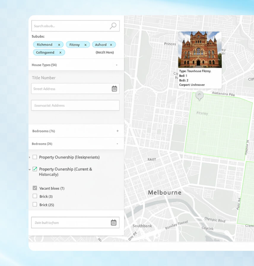
A UK-based legal tech provider wanted to simplify property conveyancing by integrating UK Land Registry data with planning and environmental datasets. The goal was to give legal professionals, surveyors, and buyers a single GIS-driven platform to visualize ownership, restrictions, and environmental risks for faster decision-making.
The conveyancing process relied heavily on fragmented records and manual checks across multiple portals. Legal professionals faced delays in retrieving property ownership data, struggled to analyze planning restrictions, and lacked an integrated mapping solution. This created inefficiencies, higher operational costs, and increased legal risks in property transactions.
Tuvoc developed a custom GIS platform (Convey Intell) powered by PostgreSQL with PostGIS, Laravel APIs, and Martin tile server for high-performance map rendering. Interactive layers were built using Mapbox GL JS to display ownership boundaries, conservation zones, flood risk areas, and other planning constraints. Users could search by title number, address, or coordinates and instantly retrieve property and legal information.
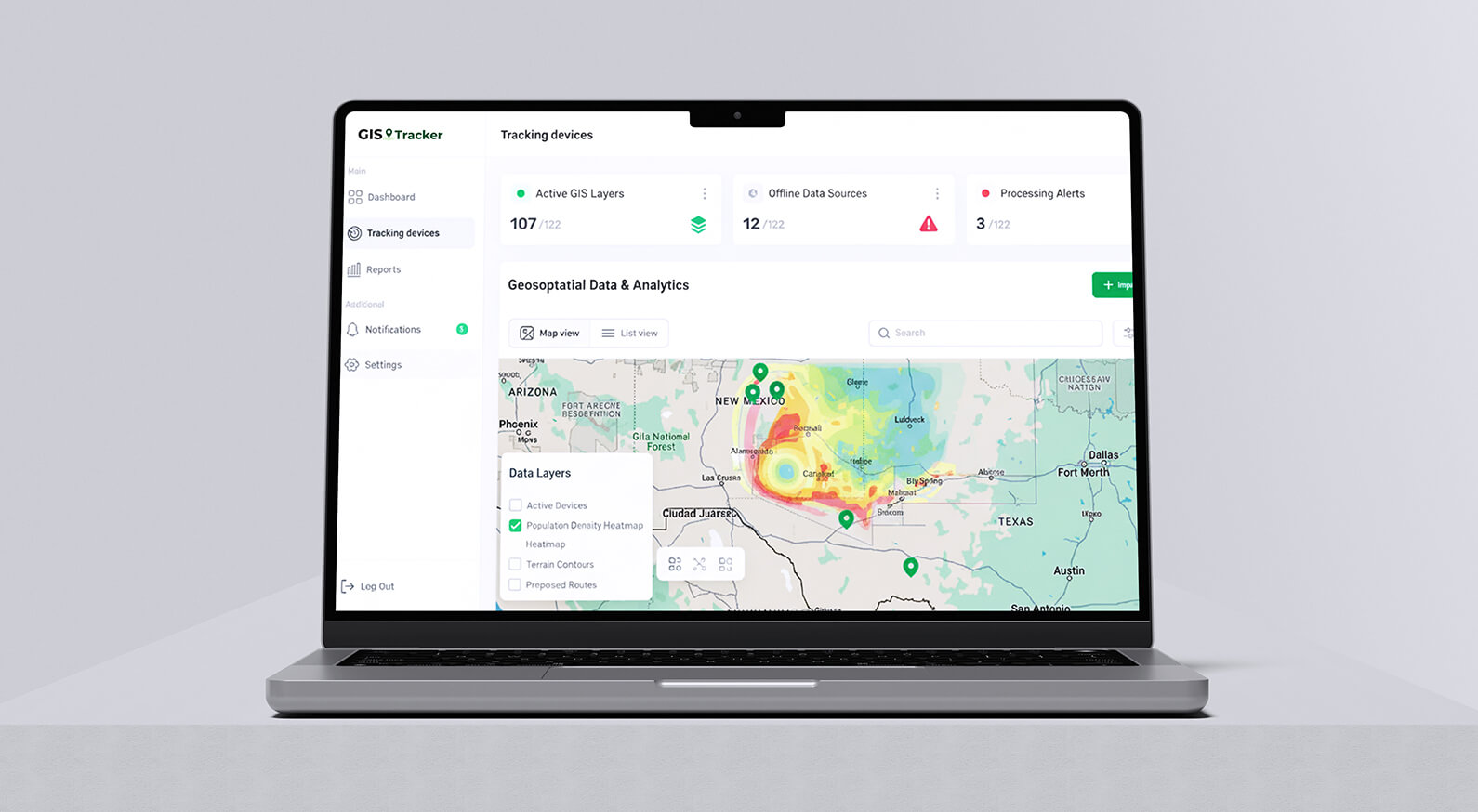
A metropolitan city authority needed a smarter way to manage urban growth, infrastructure planning, and data-driven decision-making. Their existing paper-based maps and siloed systems slowed approvals and resource allocation.
The city was struggling with outdated mapping, lack of centralized spatial data, and slow manual approval processes. This led to inefficiencies, higher project costs, and delays in executing infrastructure projects.
Tuvoc developed a cloud GIS platform with real-time interactive mapping, spatial analytics, and centralized dashboards. The solution consolidated data from sensors, ERP systems, and surveys, providing accurate visibility for urban planners.
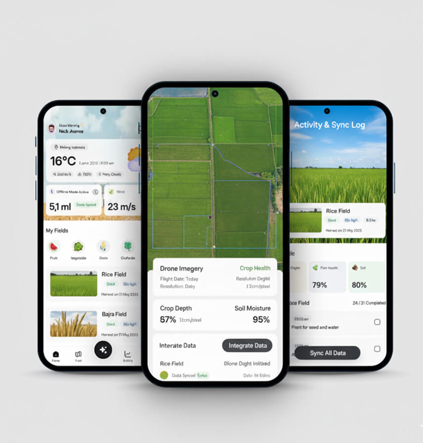
An agritech company supporting farmers across multiple regions wanted to improve crop yield predictions and resource planning. Limited connectivity and manual data collection restricted efficiency.
Farmers faced difficulties gathering and updating field data in remote areas with poor connectivity. The lack of accurate spatial data impacted yield forecasts and created inefficiencies in irrigation and fertilizer usage.
We delivered a mobile GIS application with offline data capture, drone imagery integration, and AI-powered spatial analytics. Farmers could now collect and sync geospatial data even in low-connectivity zones.
A global logistics provider required better visibility of shipments, route optimization, and real-time delivery updates to reduce operational inefficiencies.
Disconnected systems led to frequent delivery delays, higher operational costs, and limited real-time insights into shipment tracking across regions.
Tuvoc built a cloud GIS logistics platform integrating geofencing, real-time vehicle tracking, and predictive analytics. The centralized system allowed dynamic route optimization and improved customer communication.


Tuvoc Technologies delivered on time and was responsive. Their commitment to delivering high-quality solutions and forging long-term relationships with customers was amazing. After the platform launch, there was a 40% increase in user engagement and a 25% rise in customer satisfaction.


Tuvoc Technologies delivered a secure and highly efficient web platform for financial management, boosting user participation by 40% and reducing transaction times by 50%. The team used Agile methodologies, was highly responsive, and quickly adapted to changes. The team's expertise stood out.


Thank you, team, for your service. You did a fantastic job. I worked with many teams for software development, but you guys gave me a really overwhelming experience. You guys really gave us experience like family and friends, more than any professional relationship. Thank you so much again. Keep it up.

We have worked with Tuvoc for several years, and they have consistently delivered high-quality work on time. Their diligence, attention to detail, and proactive communication have made them a reliable partner to develop and maintain the performance of our product.

Thanks to Tuvoc Technologies’ work, the client saw a 40% increase in online transactions, a 25% increase in customer retention, and a 30% reduction in transaction processing time. The team was responsive, attentive, and customer-oriented. They maintained clear and consistent communication.
Receive personalized consultations from our GIS experts. Get practical insights on how we convert spatial data into scalable business solutions.
Get a Free Quote
Innovation to solve real-life problems serves as Tuvoc’s backbone. Being a reliable GIS solutions provider, Tuvoc provides geospatial application development in planning communities, improving logistical visibility, and monitoring real estate properties, among others. Not only institutions, but the entire industry becomes intelligent, efficient, and resilient using our geospatial intelligence solutions.
Custom GIS software for urban planning and GIS software for urban planning & smart cities are our basic innovations. Our solutions enhance governance and improve resource allocation and services to the citizens through data-driven dashboards and interactive visualization platforms, from zoning analysis to infrastructure planning.
We offer GIS development for logistics and supply chains to improve route visibility, fleet control, and GPS tracking. For both customers and fleet operators in delivery, transport, and distribution, products become GPS-tracking assets. Improved visibility not only improves customer satisfaction but also offers operational liberty and efficiency.
We construct GIS devices that computerize utilities and assets. Utility providers are able to monitor equipment, maintain a maintenance schedule, and minimize downtime. Our GIS solutions simplify the working processes, enhance accuracy, and manage to extend the lives of assets more economically and intelligently.
Tuvoc innovates GIS mapping and analytics platforms for agriculture that supervise crops, soil health and irrigation. Farmers can receive timely information, optimize assets, and increase harvest. Our GIS applications do not only ensure sustainable agricultural practices but also involve geospatial intelligence being integrated with precision farming that is based upon data.
Our custom mapping app development for real estate with geocoding and location analytics is proven to be among the best. The property developers and investors can access the best properties, evaluate the possibilities of community building, and make prudent choices. Our GIS systems make site selection easier, profit-driven, and risk-averse.
Tuvoc offers real-time GIS tracking software solutions that are used for disaster management. Our GIS platforms enable Government to monitor disasters and allocate resources accordingly. GIS applications equipped with predictive analytics help agencies save lives during disasters like hurricanes, earthquakes, wildfires, or floods.
One of the critical services is geospatial data visualization services that help Tuvoc turn geospatial data into visualizations to track environmental changes and predict possibilities. Monitor mountain ranges, waterbodies or air quality to meet compliances and conservation goals. Tuvoc’s GIS solutions help promote sustainability goals to preserve ecology.
Our GIS platforms are used in integrating construction and infrastructure projects. Our tools are accurate in mapping, spatial intelligence, and risk assessment that spans from feasibility studies up to the project undertaking. The large-scale projects better give the engineers and the developers better control, less cost, less time and fewer wrongdoings.
At Tuvoc, we focus on adding measurable value to businesses through geographic information system development. We build solutions with on-demand scalability, cybersecurity features, and predictive analytics. So that businesses have better geographic understanding, a knack for accurate decision-making, and enhanced efficiency.
Logistics, utilities, or safety leverage our live real-time maps and dashboards. Operate more timely and quickly, and enhance the coordination with precise geospatial intelligence.
Utilize spatial analysis to organize fleet distribution, agricultural land, or real estate properties. Thus, improve productivity and sustainability by cutting operational costs.
Maximize precision with 3D GIS modeling and raster/vector data. Get secure geospatial information to aid in planning, location preference, and development of infrastructure.
Integrate GIS systems with ERP, IoT and CRM. Run operations smoothly using geospatial intelligence in the business processes of large-scale enterprises.
We innovate web and mobile GIS solutions with offline capabilities. Expand with ease with your data, users and business needs as they keep on expanding.
We focus on protecting valuable geospatial information. Our stringent data security policy and blockchain for geospatial data security ensure compliance and privacy.
We deliver scalable, secure, and customized geospatial software development platforms built on advanced GIS architecture, open-source technologies, and in-house infrastructure.
We utilize Leaflet to produce lightweight interactive maps. It is easy, quick, and therefore ideal in the development of responsive Web-based GIS apps using OpenStreetMap data.
Our GIS software developers use OpenLayers for creating feasible and practical browser-based mapping tools with several integrated layers and data files.
Mapbox helps us build tailored maps, visualizations, and location-driven experiences. Businesses can add geospatial insights to our innovation to enhance GIS applications.
CesiumJS is a high-performance 3D geospatial visualization tool that we use to build real-world models and digital twin applications in complex projects and industries.
Our skilled team for QGIS software development customizes this open-source framework to integrate enterprises, analyze geospatial data, and create geospatial visualizations.
GeoServer is configured to publish the geospatial data. It allows businesses to exchange, update and coordinate spatial data in real time.
With GDAL/OGR, we manage modification of raster and vector data. Our techniques guarantee interoperability between various geospatial applications.
We scale the PostGIS with the PostgreSQL to provide spatial database capabilities to simplify complicated queries, accurate indexing, and evolve GIS application functionality.
Tuvoc customizes ESRI ArcGIS’ enterprise suite through ArcGIS customization and integration to deploy large-scale GIS, advanced analytics, and visualization.
The ArcGIS API for JavaScript is used to make advanced spatial applications, dashboards, and other dynamic web maps based on the needs of enterprises.
Our application combines the Google Maps Platform, which offers geostatic packaging, route creation and location functionality to the GIS applications across the globe.
We leverage Martin Tile Server to efficiently serve vector tiles for GIS applications. It is lightweight, highly performant, and designed for scalability, making it ideal for projects requiring real-time rendering and rapid map tile delivery. Martin supports PostGIS as a data source, ensuring seamless integration with geospatial databases for faster, reliable, and flexible map solutions.
Behind every project is a business challenge solved and measurable results delivered. Explore how our custom software solutions have transformed operations and created competitive advantages for our clients.
Increase in productivity
Return on investment
Countries Served
5-star reviews
We design GIS solutions that meet global regulatory frameworks, ensuring legality, interoperability, data privacy and security across all regions.
WMS, WFS, WCS, GML, and GeoPackage are some OGC and ISO standards. We ensure to adhere to them for accurate spatial data transmission and frictionless GIS interoperability.
Tuvoc subscribes to GDPR and CCPA compliance, HIPAA compliance, and the DPDP Act. We ensure the location data and personal information are secured. We deliver stringent data governance employing rigorous privacy policies.
We implement ISO 27001, NIST, FISMA, FedRAMP, and SOC 2 Type II standards in our GIS software to prevent cyberattacks and protect sensitive geospatial data and cloud GIS environments from risks.
Our GIS solutions are designed to comply with FGDC, INSPIRE, NGA, and export control standards. We ensure that our GIS software wholly aligns with regulations for defense, public sector, and global geospatial data projects.
We ensure that our GIS software is fully integrated with EPA, UN-GGIM, and FAIR Data Principles. Thereby, we ensure environmental GIS applications stay reliable, accessible, and globally viable.
We build GIS applications that are user-friendly and accessible to every stakeholder. For delivering superior user experience, we strictly follow WCAG 2.1 and Section 508.
We combine innovative expertise and industry knowledge and merge them with next-gen technologies to engineer future-ready custom GIS software development solutions that deliver accuracy, versatility, and performance.
We leverage advanced AI and machine learning models to build GeoAI that efficiently predicts outcomes, uncovers trends, and delivers actionable geospatial intelligence.
We build applications for IoT devices integrating GIS dashboards. It enables real-time monitoring, automates alerts, and tracks assets smartly across industries in real time.
Our cloud GIS solutions are deployed on secure hosting infrastructure, offering auto-scalability for effective collaboration, data exchange, and access control from anywhere.
Our 3D GIS models and digital twin applications are utilized in planning, analysis, and visualization and assist businesses in simulating and running real-world environments.
Real-time insights and predictive modeling are made possible with geospatial big data analytics. Tuvoc drastically accelerates large data for precision decision-making.
We provide AR-enabled, spatially computing, and dynamic GIS experiences to businesses for visualization training and training with real-world, interactive mapping.
Our location-based services (LBS) development uses geofencing, GPS, and beacons to deliver real-time insights and open opportunities for businesses to engage customers.
We are using blockchain for geospatial data security to make spatial applications more secure and in line with data integrity, data privacy, and regulations.
Our geospatial application development process is trusted, tested, and built to provide exceptional quality and efficient application and scalability for understanding requirements and receiving feedback to provide strong support and maintenance services.

We examine the business requirements, data sets and objectives. It assists us in coming up with GIS solutions that help us align with your objectives and the goals of the industry.

Our design architects in close coordination with our engineers, design a system that is tailored to the business needs, secure against cyberattackes and scalable.

We formulate agile development strategies and rely on frequent client inputs to continuously test applications to build on-time and incredible GIS solutions.

We provide GIS system migration & modernization services, including deployment, integration, and performance with post-launch services for frictionless operations.
We have GIS expertise in various industries. Having the experience, Tuvoc provides dependable, customized GIS solutions that eliminate complicated issues across the sectors globally.

At Tuvoc, we believe in seasoning our approach. Our GIS development methodologies have been tested over the years. Therefore, we are able to provide reliable GIS solutions within the budget, meeting the business objectives and ensuring long-term growth.
Our agile development approach in developing GIS solutions guarantees progress of delivery on an iterative basis. Ours is an altruistic approach with continuous client engagement. It ensures we deliver results quickly with optimum quality.
Our MVP-first approach creates functional GIS prototypes at the earliest stages of development. Consequently, we are able to validate products and user feedback quickly. We minimize financial and developmental risks prior to spending on full-scale development.
Besides agility, we rely on Scrum to develop GIS projects. We break the development process into manageable sprints and equip the process with defined roles, frequent updates, and clear communication to execute the project in a secure and phased manner.
Our devops best practices allow integrating development and operations, presenting GIS applications in response to service (applications) faster and more reliably with automation and constant performance reporting.
We have achieved excellence in leveraging conventional and emerging technologies. Our team determines the best suitable technology mix for your project to ensure scalability, security, and performance in our custom GIS solutions.
Being a transformative GIS development company, Tuvoc delivers innovative, reliable, and scaled solutions. Tuvoc has been the trusted technology partner that helps businesses leverage geospatial intelligence to satisfy their customers and grow steadily.
Tuvoc being an affordable software development company in India, provides resource-savvy GIS solutions. We emphasize industry standards and requirements. Accuracy, scalability, security, and reliability in GIS applications ensure quantifiable gains.
Versatility, adaptability, speed, and transparency are some of the values we do not compromise on while developing the most potent GIS applications through agile methodology. Ours are high-quality GIS apps that align with your business goals.
Tuvoc pioneers in engineering highly functional cloud-based GIS platforms. The faith in our cloud-based engineering ensures our GIS applications are capable of handling growing data and user volumes and enlarging operations with secure access and reliability.
We combine artificial intelligence with our GIS engineering for precise and potent data analysis. Our GIS solutions enable smarter and more data-driven decisions in industries through predictive modeling and real-time insights.
We ensure to weave our GIS applications with IoT devices, CRM, EPR, or other enterprise-grade applications. This collaboration ensures that the workflow is unified and silos are minimized or eliminated to gain more operating liberty and efficiency.
Tuvoc is recognized for offering incredible lifecycle support for its GIS applications. As a provider of post-deployment consulting and maintenance, Tuvoc keeps GIS solutions optimized, safe, and available to accommodate the future needs of business.
The development of custom GIS software facilitates the development of unique solutions to the unique business requirements and not off-the-shelf GIS software, which only offers a limited number of functions, is less versatile, and can’t be scaled easily.
Our data types are raster data, vector data, drone imagery, satellite image and LiDAR. We have the required knowledge, which makes us handle data correctly in the industries where geospatial intelligence is required.
Yes. We combine GIS software and ERP as well as IoT, CRM, and tracking devices. Our solutions guarantee the smooth workflow and accurate decisions throughout the system.
At Tuvoc we focus on specificity of usage to leverage any of ArcGIS, QGIS, Mapbox, Leaflet, OpenStreetMap, PostGIS, Google Maps APIs, and SDKs based on requirements for sophisticated mapping, illustration, combination and geospatial app development.
Stay updated with articles that share practical tips, industry news, and thoughtful commentary on digital trends.
Key Takeaways Core Mechanics: We define the exact hardware and software routing the money across networks. Supply Origins: You will…
Key Takeaways Scale Requirement: You need massive monthly ad spend to justify the fixed engineering costs of building. Control Factor:…

Key Takeaways Architecture: We look at the actual code difference between a waterfall setup and a header wrapper. Yield Impact:…

Thank you for getting in touch! Kindly fill the form, have a great day!


